

Introduction
Site list (GPS fixes) Walks (GPS tracks) Video clips Panoramas
Electronic projects:
Bat detector
Lamp tests
µ-controlled lamp
SEPIC-based lamp
ISP isolators
Making SMT boards
Expedition logs:
Spain 1973, 1974,
1975, 1976, 1977,
1979, 1982, 1983,
1985, 1986, 1987,
1988, 1989, 2000,
2001, 2002, 2003,
2004, 2005, 2006,
2007, 2008, 2009,
2010, 2011, 2012,
2013, 2014, 2015,
2016, 2017, 2018,
2019, 2020, 2021,
2022, 2023
Mexico
New England
Translation:
Expedition log, Summer 2003
A summary and index of the Speleogroup logbook.
Andinas, Bulnes, Trumbio, Viango, Cueva Negra, High Picos etc.
| Date | Activity |
|---|---|
| 01.07 | Bill just misses his flight from Milan, but re-routes through Barcelona and still arrives in Bilbao an hour before Mike (who travels via CDG). We drive the hired Citroen Xsara directly to Llanes (with a stop for a snack in San Vicente), arriving around 18:00. Wanderered around the town for the evening, noting new buildings, etc. Supper in Rte. Covadonga; paella for both then sardinas for Mike and chuleta con queso (Cabrales sauce) for Bill. |
| 02.07 | Bill’s birthday! Breakfast at 08:30 then an early start at 9 for the Andinas area (see log for 22 June 2002).
First scouted tracks from the ‘main road’ for ways up to the depression
shown on the map; the track we chose had an easy cement surface and
the Citroen behaved admirably.
 Depression above Andinas Well, we had better make our exploration thorough, so we first proceeded up-valley – due West – looking at further depressions. Many had tell-tale clumps of trees but no cave at the bottom; most promising is the westernmost, at N43°20'59" W4°34'46". Using radios for communication, we split up to circle around and into the major, lower, depression. Obstacles included barbed wire and feisty cows and bullocks. Alas the final “sink”, at the usual clump of trees (📌) was totally blocked by mud and brambles. The 8.6km of walking raised a fine appetite; so on to lunch in La Hermida @ 13:00. Sopa montañes and Cabrales de Treviso for Bill, chuletillas for Mike. Peña Prieta (tinto) for both.
 Bejes Refreshments in Panes before driving up to Suarías and then to Cabañuca (following a very slow lorry all the way, passed 100m before the cave’s depression), locating the cave with the new GPS at N43°18'08" W4°34'18". Alas, while taking the 60-second measurement, our retreat was cut off because the lorry had dumped its load of grit onto the road – between us and Suarías! We drove back in the other direction to find a large wooden stick, then returned to the gravel heap and laboriously dug our way through; back to Llanes via Unquera around 18:45. The rest of the evening spent selecting a suitable restaurant and menu for Bill’s birthday dinner. Eventually decided on the “U-shaped one” in the alley (Casa Canene); Merluza a la Romano for Bill, Escalope for Mike; Rosada. |
| 03.07 | First destination El Mazuco from the west, after first predicting the position of the shrine (Ermita del Santo Ángel) at the junction where the village road leaves the ‘main’ road (prediction: 📌).
 Belugo entrance By now the 150m error at El Mazuco junction had been determined to be due to using the wrong datum (the GPS device default is WGS84). On correcting to EUR50 coordinates the position matched within a few metres. [Note: GPS readings on this website are EUR50; links to worldwide maps automatically use WGS84 – for more details, see the Coordinate systems page.] On to Arenas for an excellent lunch at the restaurant with the triangular dining room (at the major junction); [Restaurante Café Cares].
 Bulnes gorge Nothing much of speleological interest. Fortified with excellent Cabrales cheese de Bulnes and two tintos, we were inspired to walk all the way down the gorge, even though we had return tickets. Spectacular! Much easier down than up on the narrow path. On the way back, we crossed the bridge to Allende/Los Callejos, and drove up the track towards La Montaña Mágica, looking for a good route to Cueva Samoreli. The best track is on the right before Allende from the car parking spot (at 📌) and leads directly to within 50m of Samoreli. The hayfield in front of Samoreli is now completely overgrown with brambles so Bill descends Pozo del Molino, takes photos, and does through trip with a red 1W Luxeon LED light. Back to Llanes and eventually the same restaurant as 2 July. |
| 04.07 |  Gueyu Reinazo Then up to K4 on the road to the lakes, with an early stop to locate and look at the Gueyu Reinazo resurgence 📌. From K4 it is but a short walk around a small hill to the depression and entrance of Trumbio, last visited in 1979 and still an impressive cave. The main purpose of the visit was for testing our LED lamps in real cave conditions.
 Bill & brunette Still enthusiastic, we return down out of the clouds, then head east. First take a loop south of the Cangas-Posada road, west of Benia, to look at the cave and resurgence near a caving/exploration school. Then, having spotted a depression on the map right next to the track due south of Benia, we head up the track. Bill, having dry boots (at the time), headed off down into the depression and streamway, while Mike manned ‘base station’. The grass was long and wet and a few drops of rain were falling. Soon the meadow terminated in trees but there were evident paths down following the dry bed of a stream. Quite suddenly the way became quite steep and the dry streamway dropped down dry cascade steps of 1–2m. The cave, “El Peruyal”, is a 20m × 10m entrance in a cliff face 📌 with about 100m of big walking passage. |
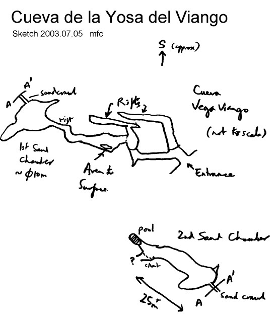
| 05.07 | Destination Cueva de la Yosa del Viango, first visited in 2001; dry at the coast, overcast in the Sierra. The track up from
Purón is now complete, so we were able to drive up almost to Pruneda
and parked the car 📌, then headed
west up the valley. The first speleological feature of note on the
walk to Viango is the Fuente Grande (1.4km from the car 📌), which is a resurgence with 1m × 1m and
a fair size stream giving a very wet passage which might ‘go’ (too
wet to explore in walking gear). Fuente Chica proved elusive.
 Viango from Collado la Raiz
 Viango cave entrance The best route, however, proved to be under the daylight aven and across a pile of sticks and rubbish. After a low rifty muddy section, this leads into a good-sized chamber with sand banks and side passages, one an aven/inlet with a fine echo. Under a low arch, an easy-to-miss sand crawl leads from there to another sandy-floored chamber which winds on for 25m+ and ends in a deep clear pool (no obvious way on at that point). To the left before the pool is a 4m climb with a fixed rope (possibly leading to a bypass). Not having SRT gear at this point (and the rope being attached to only a single bolt), we declared the cave ‘done’. All-in-all somewhat more than we expected and worthwhile. Other than the rope, there was no evidence of previous exploration as presumably water backs up in the winter and removes any footprints, etc.
 Mike in Viango cave On exit from the cave the mist had turned to drizzle, most of which evaporated as we walked, but it was a long slog back to the car. Lunch was sorely missed. (Times: left car at ~11:15, back at 17:15; about 2:15 up and 2 hours down, the rest in the cave.) A new bar had been noticed on the road outside Purón, so a large plate of queso (+pan y vino, all for €6.60) was rapidly demolished. Back to Llanes for dinner at the newly re-opened “restaurant across the bridge”. |
| 06.07 | A walk/Llanes/recovery day; Mike walks along the cliffs from Paseo San Pedro to Poo, where an extremely serious game of 10-pin bowling (approx.) was in progress. After observing this for a while, back to Llanes for lunch of an excellent merluza a la plancha at La Marina restaurant in the port. Lazy afternoon writing up the log. (Clouds over the mountains as usual. Sun in morning then cloudy.) |
| 07.07 | A reconnaissance day, investigating three areas:
Back to Llanes then dinner at Casa Poli (Puertas de Vidiago) – very pleasant and surprisingly busy for a Monday. |
| 08.07 |  Cueva Negra entrance We left the car at 11:15 and proceeded up the steep track at a rapid rate in bright sun/cloud. Good views of the Tinganón upper-entrance depression, and noted a secondary depression SE of Tinganón which could provide the stream for the Tinganón inlet. In our enthusiam, we deliberately overshot the spectacular entrance to Cueva Negra in an attempt to orient ourselves with our exploits of 2002. However we were unable to recognize any feature for certain, and eventually decided that the next depression would be “too far”.
 Bill in Cueva Negra Checked out the supposed Tinganón feeder on the way back, but the promising cliff face revealed no cave. Back at the car at 15:15 – a good 4 hour walk & cave with GPS record. There appears to be no bar in Santianes, but we stopped soon after on the main road at a cheap hotel-restaurant for a cool beer. Using the GPS as a guide we set about looking for the “Madre del Río” resurgence to the Negra system. We did locate the Bahrua(?) hostel and spoke to the owner who remembered Frank Nicholson and Liverpool students. MdR, she said, was to be found 500m further west at the foot of the (now) Eucalyptus woods (we didn’t find it), and possible further abandoned resurgence entrance higher in the woods. Snack in Purón, dinner at Terraza in Llanes. |
| 09.07 | Back west to look for the ‘Madre del Río’ resurgence again, this time from the south-east of
the building site for the new industrial park. Eventually found
it below the hillside, in a valley filled with 2+ m-high bracken.
The water bubbles up through impenetrable gravel at N43°26'02" W5°00'18".
Mike then (foolishly? heroically?) did a traverse through the Eucalyptus forest above, below a possible cliff face. After testing the load-bearing attributes of a 10cm Eucalyptus log (failed under 60kg load, depositing said 60kg load into bramble bushes), and much thrashing about in brambles and gorse, declared very little chance of anything of speleological interest. We also investigated other possible resurgence sites, (possibly older exits) further east, finding just one, at 📌. Lunch of wild boar stew and bonito/anchoas at Arenas. Over lunch we discussed three possibilities for the afternoon’s excursion. The peaks seemed hazy so we dismissed the Funicular to Bulnes. The initial path to Caín was steep and in the time available we would never reach Caín (and bar!). So we decided to drive up towards Sotres guided by speleological features on the map. We were delighted to find that the old landrover track above Sotres had been tarmaced so we proceeded up to the spectacular pass (Cda Barreda) at 1317m. At this altitude there were many grassy hillocks, not just bare limestone – quite good for walking.  Sheep and karst near Tresviso Tresviso is the end of the road, so back up to the pass and down to the lower pass (Colláu La Cabellar, 2km west of the 1300m pass) and noted caves marked on the map. After 15 minutes walk we found the larger (shown as (8) on the map, Torca Labarga, 361m deep) and explored the large entrance 4m high leading to a steeply descending vadose passage 15m high (with avens leading to daylight). Turned back at the top of pitch > 5m deep; the cave continues into a chamber. When then split up, using radios for communication, to check out depressions and contour back to the road by different routes. Mike finds a further deep depression just below the entrance just explored (but no evidence of cave). Bill retraces steps then contours above for a view of the big valley (and track) and said depression. Drive back to Llanes for a much-needed shower before going to the sidrería Cabañón in Naves for sidra, Rioja (Muga), and raciones or chuletillas, queso, chorizo criollo, lacón con patatas... |
| 10.07 |  Crags above the mines As we drove south the weather improved, and there were no queues at Fuente Dé so we were on the Teléferico at noon. At 1835m it was only slightly cooler. As in 2000, we proceeded north over the saddle in the direction of the Refugio de Áliva, but bypassed this bar-restaurant by contouring around a rough footpath towards the mines (the Minas de las Mánforas at about 1550m – mines for blenda, zinc ore). The mine buildings and spoil area are popular with herbivores, as are the cool mine entrances!  Mike inspects a mine It was now 14:30 and we were feeling hot and hungry. A long walk up the hill took us to the Refugio de Áliva at 1666m (📌), where washing our hands in spring-cold water was an especial pleasure. The menú del día was chickpeas and spinach (for Mike) and ham and melon (for Bill), followed by merluza a la romana for both. The Rioja was Royal Claret; all, including water, was €26. Thus refreshed, we returned slowly up to the saddle at 1935m, where we decided to turn right (NW) towards Hoyo Sin Tierra. We continued only 500m along the flat before turning back as it was getting late. Back down to Fuente Dé; stopped at La Hermida for refreshments then at the Vauclusian spring between Estragüeña and Puentelles to record its position 📌 before return to Llanes. |
| 11.07 | A slightly more inland route east than usual: Unquera, El Mazu, stopped to
look at depressions near Otero (pretty, but no caves). SW to Cueva
Toyu to pinpoint location: NE corner of barn (on survey) is at
N43°16'56" W4°29'09", alt 203m. Then S and
E to Puentenansa and after a little shopping start looking for lunch.
Found an admirable restaurante in Ruente (fine roast lechazo) – with, 200m away, the biggest resurgence we have seen in Spain! Perhaps 2 cumecs (in July!). This is called La Fuentona and is at N43°14'56" W4°16'02" alt 203m; at the bar they talked about a diver once going in, but not exiting [maybe]. A brief reconnaissance walk through the hayfields above showed no obvious river on the surface behind, so some research is needed (Ruente is only just on our current maps). On to Castro Urdiales and up into the hills to locate Cubilla 📌 and Cueva Lastrilla 📌. Later a light dinner of asparagus, anchovies, russian salad, etc. |
| 12.07 | Early start for Bill’s delayed 09:10 flight; Mike’s is at 13:00, so plenty of time to write up the log... |
Personnel: Bill Collis & Mike Cowlishaw.
Other log details:
- Exchange rate: 69p = 1 Euro = 166 pesetas (241 pts/GBP).
- New GPS (Garmin Geko 201), positions in °,′,″ shown using WGS84 datum.
- Notes of LED lamp tests in Trumbio (4 July).
- Sketches of Cueva de la Yosa del Viango (5 July).
- Additional waypoints to Cueva Negra (8 July).