

Introduction
Site list (GPS fixes) Walks (GPS tracks) Video clips Panoramas
Electronic projects:
Bat detector
Lamp tests
µ-controlled lamp
SEPIC-based lamp
ISP isolators
Making SMT boards
Expedition logs:
Spain 1973, 1974,
1975, 1976, 1977,
1979, 1982, 1983,
1985, 1986, 1987,
1988, 1989, 2000,
2001, 2002, 2003,
2004, 2005, 2006,
2007, 2008, 2009,
2010, 2011, 2012,
2013, 2014, 2015,
2016, 2017, 2018,
2019, 2020, 2021,
2022, 2023
Mexico
New England
Translation:
Expedition log, Spring and Summer 2019
Speleogroup made two expeditions to Spain in 2019.
- The Spring trip: Villa, Tebrandi, Boriza & Pozo de Fresno, Potes, Tresviso, Bolado.
- The Summer trip: Mazacuíos, Bufones de Santiuste, Boriza, Cobijeru, Rejo/Cofría, Tayada, Tenis.
Click on, or tap, any image thumbnail for a full-size version, or on a video clip to play at a larger size.
| Date | Activity |
|---|---|
| 28.02 | Mike arrived Bilbao on schedule, and with four hours to wait had plenty of time to review plans, maps, etc. Bill’s plane from Milan happily arrived 20 minutes early and Bill appeared landside just six minutes after touchdown! Picking up the hire car was also achieved in record time and we were soon on the road heading for our first speleological ‘site of interest’.
This was the Hoyo de Fuentejuyo sink (1.7 km SW of Ori��n) spotted on the map some months ago; in beautiful weather (17°C and blue skies) we descended close to the watercourse shown on the map but there was no detectable water and no real chance of getting to the assumed sink through dense undergrowth. So ... onward to the second objective.
 Hazas depression sink Day-one speleological objectives more-or-less achieved, we headed west via Oru�a to Llanes. It being a February Thursday, most restaurants were closed but we had a pleasant light dinner at El Almacén. |
| 01.03 | Up at 9 and a brisk walk along the Llanes harbour quayside took us to the Bit�cora bar for 2 large coffees. This still left us hungry so on our way to El Mazuco we also stopped at the Sidrer�a Jovino in Posada for yet more. We noted that they served food too!
 Bill on the way to the Villa TV mast We decided on lunch at Casa María in Mestas de Con and had the menu del d�a at �12. Fabada for both, trout for Bill and escalope for Mike. Average quality food.
 Orandi ‘Trumbio meadow’ primroses |
| 02.03 | Up at 9:30; had coffee in Uria bar and had another in Sidrer�a Jovino.
Proceeded to Asiegu (about 2km NW of Carre�a) and up the narrow unpaved
road north towards Tebrandi. Shock, horror! A vehicle coming down!
Then after passing, another driving up in the distance. As a matter
of courtesy to any landowners we parked at around 690m only to notice
that a rear tyre seemed very deflated! Would we be able to descend
without incident? Somewhat worried we walked the last 1.2km in bright
sunshine and a brisk breeze.
 Tebrandi drone view, SSW After a very slow and careful descent we checked the tyres above Asiegu village and all seemed fine! The apparent deflation was due to the uneven and sloping ground where we had parked. Nevertheless we pumped up the tyre in Arenas where we had a lighter lunch of chorizo a la sidra and patatas con Cabrales (as we were in Cabrales, the cheese sauce was above average) at Sidrería Calluenga. Returned via Panes to Llanes via Vidiago to admire the “bufones”, where the rough sea forces air and sea spray through fissures in the limestone. There she blows!
 Llanes Carnival Dinner early at Taberna Mezcolanza (the old ‘El Gale�n’) where we both had secreto ib�rico (tender roast pork) washed down with Ribera del Duero. |
| 03.03 | To the ‘Mexican’ caf� for breakfast coffee; the caf� sported a number of people in carnival costumes and drinking beer; presumably the bar had stayed open all night.
 Drone pic of possible Boriza upper entrance Next back via the ‘car paddock’ 📌 to fly the drone over Pozo de Fresno, both Mike and Bill piloting, to again take advantage of no leaves on the trees – although the white Ash twigs acted quite effectively as a net curtain.
 Bill in cave by the road to Playa de Cuevas del Mar Perfect weather again, so then North to the Playa de Cuevas del Mar for various explorations of many small caves at the beach and a little inland. Then, as the wind was picking up ahead of storm Freya, a longish walk to the Bufones near Llames; spectacular waves, more noisily-venting holes, and spouting sea-water geysers. |
| 04.03 | The weather forecast had predicted a cold and very wet day but blue skies and sunshine welcomed us yet again when we got up at the usual 9:30 for breakfast. Nevertheless we persisted with the ‘wet’ plan, driving south from Unquera and up the Deva Gorge. Due to lack of safe parking places we cancelled the drone flight up to Pozu del Infierno entrance, so our first stop was at La Hermida. La Cuadrona, where we had hoped to get a plate of Pic�n de Bejes (blue cheese), was closed, but the Bar Restaurante Paquin was open and we had a small glass of Rioja.
 Riega Cicera stream Returning to Llanes we stopped on the coast to watch (and hear) the Bufones at Vidiago. The sea was rough and we were rewarded by high waves pushing air and salt sea spray through caves. There she blows! Most restaurants in Llanes were closed outside the weekend but Uria was open, where we were served by the same lady as 40 years ago! Paella for both then lomo for Bill and filete al Cabrales (with blue cheese sauce) for Mike. |
| 05.03 |  Sotres/Tresviso walking
 Sotres/Tresviso view from carpark
 Mike in Cueva Bolado Back to Llanes via Posada, but as it was relatively early and we were feeling keen, we diverted to Cueva Bolado for some real caving. Almost found the main route on the first try, and soon got to the main sandy cavern at the end; the stalagmites looked amazingly pristine and white. The big surprise was finding a stream in the cave that we’d never noticed in summer visits; on exiting we soon found its resurgence. Back to the hotel, and another dinner in Almac�n (remarkably few restaurants being open). |
| 06.03 | Because of Bill’s early flight on the 7th, today was a travelling day
to move closer to Bilbao. As we paid the bill at Hotel Sabl�n we
were pleasantly surprised to receive a gift of local cheeses at reception!
We drove east via La Borbolla (with a walk towards the resurgence,
and noticing an orange tree ‘in fruit’). No sign of any abandoned
high level resurgence was seen notwithstanding the lack of obscuring
vegetation at this time of year.
Next stop was Restaurante Las Filipinas in Comillas for a drink before proceeding to Puentecilla for lunch. We had a relatively expensive men� del d�a at �17 each. The merluza (hake) stuffed with mushrooms was good and unusual.
 Castro Urdiales promenade After lunch there was some light rain and we arrived in Castro Urdiales at 15:30. Went to the ‘green bar’, checked into the hotel Las Rocas, then (as the rain had stopped) walked round the town. La Marinera bar and many others were closed. Later, it started raining more seriously as we were writing up the log, so dinner in the hotel cafeter�a (the restaurant was ‘closed’). |
| 07.03 | Up early to catch Bill’s 10:45 flight; uneventful travels except atrocious driving weather in the UK. Mike makes up for a week of few vegetables with a seriously veggie lunch. |
![[360°]](files/2019/Tebrandi-0410-360pan.jpg)
| Date | Activity |
|---|---|
| 19.06 | Bill up at 5:30 and on his way to Malpensa airport at 7:30 arriving
at 9:45. It took just 5 minutes to get off the plane on time at Bilbao.
The Europcar office recommended the Loiu Sidreri about 5km away for
a self-service lunch (€16) (as much food, wine, cider, and beer
as you like). Good value.
Then to Castro Urdiales and La Marinera bar. When Mike’s ETA was
postponed for the second time to 22:30 (from 21:00) Bill had 3 pinchos
and 2 Riberas as a substitute for dinner. Then back to the airport
again but on arrival learned that Mike’s flight was cancelled. Bill
decided to head for Montemar Hotel in Llanes as four local hotels
were full; arriving at 12:30 (200km from airport).
|
| 20.06 |  Arrendondo lunch We took an inland route towards Solares and detoured to El Coladillo (1km S of La Cavada) to look at a large depression taking a stream. But, lacking appropriate gear, we didn’t actually see if there was a real cave entrance – turning back just 25m from the presumed sink 📌 near a waterworks building. After stops in Torrelavega and Pendueles, we arrived in Llanes in the drizzle to book into Montemar. Then dinner in Canene (€18 for 2). |
| 21.06 | Dark skies and light rain, as forecast, didn’t stop us foraging for
coffee and a shoehorn before heading Southwest to Ortiguero. As
we drove the rain happily tailed off, and we carried on to Arenas
where a walk-around revealed no significant changes since March.
Next East down the Cares river valley, with a stop at Casa de la
Molinuca (600m S of Cueva Llon�n). Then on to La Hermida for the
(now traditional) queso pic�n, followed by lunch (lomo for
both).
 Cueva Mazacu�os, La Franca Back to Llanes via Pendueles. |
| 22.06 |  Boriza resurgence stream Disappointed, we retreated by a different, even muddier, route to the car and from there to the Roxin bar-restaurant at 13:00. Chorizo criollo and patatas alioli plus a jug of red. Later, for dinner, Bill had secreto ib�rico (tender pork) while Mike ordered merluza a la plancha (hake) at the taberna Mezcolanza. |
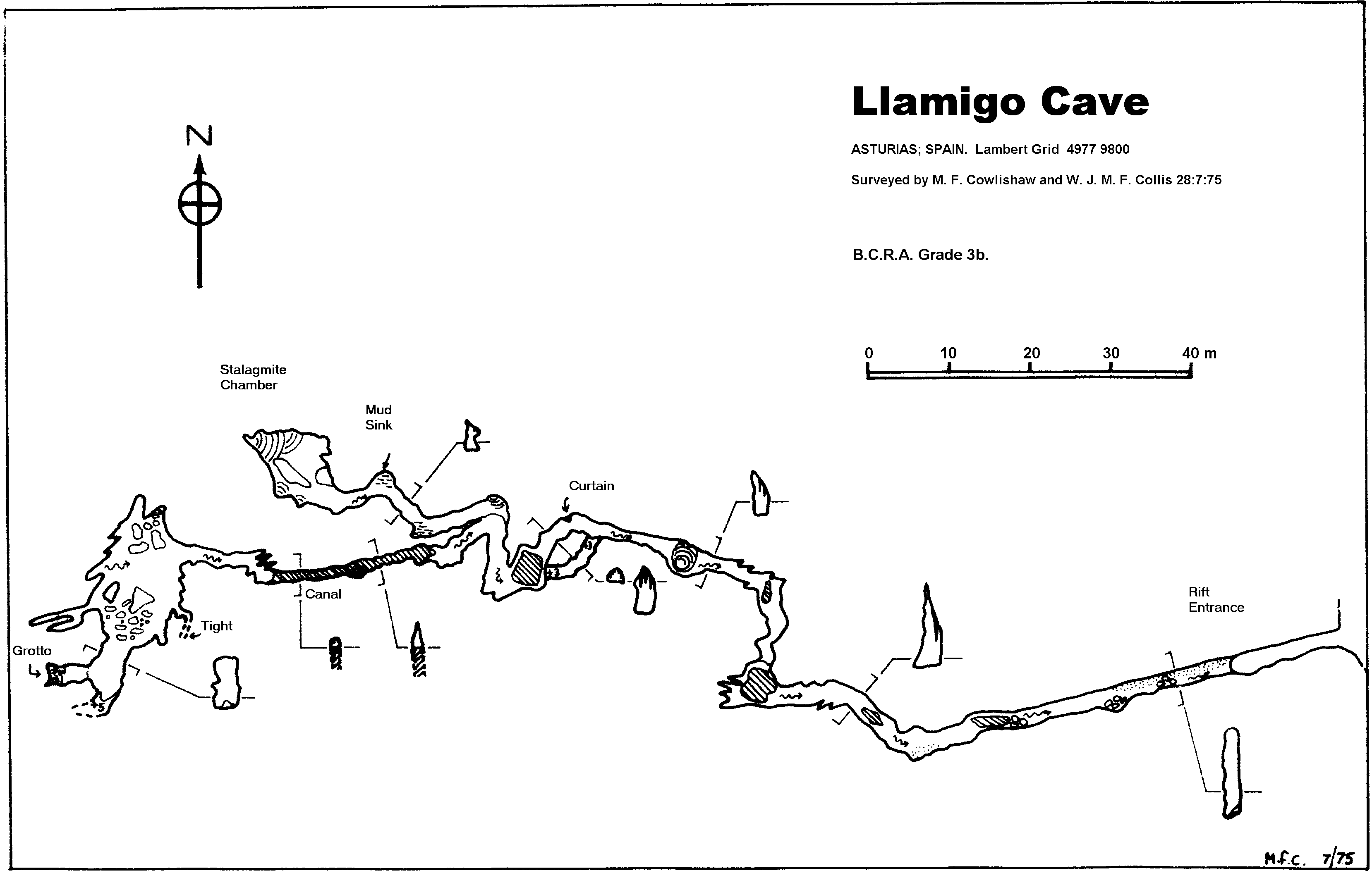
| 23.06 | Cloudy start – just a few drops of rain as we drove West to Nueva
and thereafter increasingly pleasant and sunny weather. The objective
this time was the Llamigo resurgence cave, in the Reguero la Friera,
which we surveyed in 1975, with a new approach
plan to get to it from below. Logging road soon found (just before
[North of] the first bridge over the Río Nueva, some years ago
the start of an epic drive up towards Cueva Negra) about 1km S of
the ‘bypass’ around Nueva. Drove on up to the sink for the cave
📌 before returning to the bottom
of the valley and starting the walk.
 Llamigo walk monument El Sucón, near Debodes, for a good Sunday lunch of lomo and chuletillas before returning to Llanes with a stop at Puente Nuevo for dessert of excellent Gamonéu cheese. |
| 24.06 |
East to Buelna and walked to the Cobijeru inland beach and cave.
This is nice walk along a stream which sinks and resurges at intervals.
Some of the entrances appear penetrable, but are too muddy or tight
to encourage exploration. Our objective was the easy Cobijeru
cave a few metres east of the inland beach. It’s interesting because
one can get completely out of sight of daylight and the passage then
opens into a wide chamber and more entrances at sea level.
") Bill in Cueva del Rejo (Cofría) As Restaurante Gloria was closed we went North to San Vicente and had a below average lunch of merluza with too much batter (Mike) and sulas (whitebait, for Bill). We didn’t appreciate the later dinner in Llanes either – slow surly service, over an hour for one dish each, and dirty glasses. But the food was adequate; gambas al ajillo for Mike and jamón Serrano for Bill. |
| 25.06 | The weather forecast suggested a dry morning and wet afternoon so we
headed West towards a limestone patch near Oviedo; by Ribadesella
the drizzle had turned into rain, so plans quickly morphed to a show
cave (Tito Bustillo – closed) then a nearer limestone patch close
to Vallobil, 6km S of Arriondas. The area was duly reconnoitred,
including an ‘orange’ road that turned out to be an unpaved track
– but limestone was even more elusive than good weather. There
was a bar in Vallobil – but it was closed on Tuesdays...
Headed East and North to Puente Neuvo for a pleasant plate of picón followed by lunch at El Sucón. The sun came out in the afternoon – quite contrary to the forecast – so a long walk around Llanes proved possible.  Paseo San Pedro panorama |
| 26.06 |  Bill at Cueva Tayada entrance
") Sotres cave/arch (320mm equivalent) Back to Sotres for a much-needed cold beer, then via Ortiguero to Cueva Cosagra (‘Cueva Geoffo’) where there was a probable bat-detection. Tabla de quesos for dinner, followed by an unsuccessful attempt to detect bats near the Llanes river. |
| 27.06 | Blue skies in the morning so good drone weather. Drove East to
Suarías (above Panes) for aerial reconnaissance of Cueva del Arco
next to a natural cave arch overviewing one of the large depressions.
This cave was discovered on the spring 1976 trip, and revisited in
1982 and 2010.
 Suarías panorama extract Returned via Casa Poli in Puertas de Vidiago for a snack of smoked Gamonéu cheese washed down with “Pruno” Ribera del Duero. Before dinner a short trip into Cueva Bolado (out of sight for daylight) to detect bats – none heard, but it was well before sunset. However, bats successfully detected in the streets near the hotel, and near Paseo San Pedro, after dinner. |
| 28.06 | Another sunny morning so off to the East of Comillas, in Cantabria.
First plan was to check out a possible resurgence at the Arroyo de
la Mina, but this was abandoned as the valley, near La Iglesia, was
dry. Then we took a track South hoping to examine the depression,
1+ km in diameter and 150m deep marked on the map as Vallosero.
The car managed it to the 5km track which circles the depression
but this new track was so uneven we proceeded on foot. The view
of the bottom of the depression was obscured by tall gorse and eucalyptus
trees. After walking a km we retraced our footsteps and then drove
to Comillas for a menú del día in the town centre (insipid
paella but excellent lubina a la plancha).
Returned to Llanes after visiting the Bufones de Arenillas at Puertas de Vidiago, and a cool drink in Cue; stopped above Playa Tor� for a quick panorama:  Playa Tor� |
| 29.06 | Somewhat cloudy and humid at the coast, but dry. We decided to head
South where less cloud expected. First stop was Coto del Infierno
in the La Hermida gorge to launch the drone to view Pozo del Infierno
entrance, first visited in 1973 (and happily just outside the no-fly
National Park boundary). Not entirely successful as being deep in
the the gorge the drone reported ‘weak GPS signal’ and refused to
fly higher than 30m – but a nice panorama [360°] was captured.
 Pic�n de Bejes, at Bejes |
| 30.06 |  Cueva Tenis, Ribadesella After lunch a visit to the West bank of the Playa de Guadamía – impressive karst cliffs – followed by a walk among the Bufones de Pría, completing a hat-trick of bufones. Back to Llanes to pack, dine, etc. |
| 01.07 | Early start for 11:00 flight from Bilbao; brief stop for coffee in Bar Verivan, Castro Urdiales. Uneventful trips home. |
![[360°]](files/2019/Suarias-0541-360pan.jpg)
![[360°]](files/2019/Infierno-0546-360pan.jpg)
Notes:
- Exchange rate: 1.16 → 1.12 EUR/GBP (compared to 1.425 in 2015, 1.26 in 2016, 1.14 in 2017 and 2018); 85.5p → 90p = 1 Euro = 166 pesetas (194 → 184 pts/GBP).
- Petrol was €1.259 → €1.22/litre.
- Weather: essentially perfect in Spring; it could have been May or June, not March. A little rain on the final (mostly travel) day. More mixed in Summer; some rain/cloud in the first week; clear sun for final few days.
- The drone flown was a DJI Mavic Pro »;
33+32min in total.
GPX tracks of the drone flights may be available if you contact us. - The pictures in this log were taken using a Panasonic TZ100 or TZ200 camera, a Panasonic LF1, various phones, and the drone.
- 360° panoramas are very large and so are not displayed in this log; instead, click on the [360°] marker to open and then save the panorama, or right click to save directly.
- Specific GPS positions are shown by a pushpin symbol (📌) in the log above – click on the symbol for a Google Maps view of the fix. These positions are also listed on the Speleogroup site list page with coordinates in °,′,″ degrees using WGS84 datum and in UTM coordinates; see Coordinate systems.
- Fixes and tracks were recorded using a Sony Xperia Z3 Android ’phone using the MyTrails app (or by the drone, for drone flights).
- This log was almost entirely edited in the field on a Lenovo Yoga notebook, using the MemoWiki » extended Wiki notation which is then processed by a Rexx » script to generate the HTML for this web page.