
Introduction
Site list (GPS fixes) Walks (GPS tracks) Video clips Panoramas
Electronic projects:
Bat detector
Lamp tests
µ-controlled lamp
SEPIC-based lamp
ISP isolators
Making SMT boards
Expedition logs:
Spain 1973, 1974,
1975, 1976, 1977,
1979, 1982, 1983,
1985, 1986, 1987,
1988, 1989, 2000,
2001, 2002, 2003,
2004, 2005, 2006,
2007, 2008, 2009,
2010, 2011, 2012,
2013, 2014, 2015,
2016, 2017, 2018,
2019, 2020, 2021,
2022, 2023
Mexico
New England
Translation:
Expedition log, Summer 2007
High Picos, Devoyu, Caín, Rales, Sotres
New: pushpin symbols ‘📌’ represent GPS locations and link to Google maps.
| Date |
Activity |
|---|---|
| 06.06 | Wednesday. Speleogroup reconvenes in Bilbao after uneventful flights via Paris and by car from Italy. First to Castro Urdiales to check-in. Then inland for the first caving trip – Cubilla 📌, spectacular even though we went barely out of daylight. Next to Cueva Lastrilla for GPS 📌 (almost thwarted by a flock of aggressive sheep which chased us out of their field). Dinner anchoas and chuletillas in Castro. |
| 07.06 | First back to the Lastrilla road turn-off
for photos and GPS 📌 then on to the first
real caving objective: locate and record the Cabañuca resurgence.
Arrived at Cabañuca itself about 12:30 after stopping for diesel,
etc., in San Vicente and then crossed over the ridge to the west
of the cave via the cliff immediately above the cave entrance 📌. Then down the extremely steep slope (over
120m down in about 200m horizontal) towards the sound of water.
For the last part, Mike watched as Bill navigated the steep stretch
down into the shady valley to locate the resurgence 📌.
The only practical way back was up. Although easier footing than descent, the brambles, thorns, gorse, blazing sun, and putrid stench from a dead goat part way up made this a memorable climb. Once back at the car, drove down to the Deva gorge and then south. At Puente de Estragüeña we stopped and located the Fuente de Estragüeña (~200m north of the bridge, crossing under the road 📌); amazed we had not noticed it in previous years despite having driven up or down the gorge at least a hundred times. Reached Quintanilla (de Lamasón) on the stroke of 3pm, in time for a good lunch of potatoes and pork, ham, albondigas, etc. Decided that it was indeed a good place to stay, as recommended by Carlos Puch, and checked in. Still plenty of day left, so we drove back to La Fuente to investigate a new road we had spotted earlier in the day. This turned out to be the road north from Roza that we had slogged up on foot in 2002 – now much improved and passable by Bill’s car. Soon reached the top of Col de Llaves and investigated the Menhir at 1100m. Fantastic views. Continued on the track to the end at another saddle; again great views but little speleological. Back down the track to try again to find the ‘Cueva Cosangre’ marked on the map but again was unsuccessful despite much scree-thrashing on an extremely unpromising hillside. Back to Quintanilla to write up log and transcribe the 1975 log. It turned out that no dinner was available at the Posada so drove over the mountain road to Puentenansa. Nothing promising there, so on to near Luey where again there was no open restaurant so we settled for tablas of cured meats and cheese which went down well. By now it was foggy – very unusual for the time of year – so the drive back was tedious. |
| 08.06 |
Based in Quintanilla, a good weather forecast, and a weekday made
this the optimal day for a hike in the high Picos. A stop for coffee
and tortilla in Potes then Fuente Dé at 11:00. The low season
rate was €12.50pp; no queue at all, so we started walking at
11:20. Turned left (west) at the main path junction 15 minutes north
of the teleférico, then flat for a while followed by steady ascent
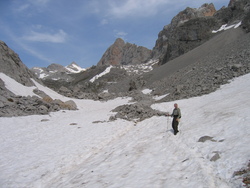
through 2007m across patches of snow. Next steeply up past Hoyu
sin Tierra then north until stopped by a deep snow slope that would
be silly in summer walking gear. Probably our highest point reached
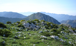
in the Picos: 400m of ascent to 2250m 📌.
Two hours up and a little over one hour down got us to Espinama just before 3pm for a good lunch of fabada and lomo/escalopines. A slow journey back with a stop at Potes, then a search for Cueva de Fair Share (BUSS 1973), which we located and recorded for later verification 📌. Stopped at La Hermida to investigate the new Hotel Balneario » at the old spa, and then returned to Quintanilla investigating various side roads, including the one to Cires. Pleasant dinner at the Posada in Quintanilla. |
| 09.06 | Saturday. An early start from Quintanilla;
coffee in La Hermida. Mixed reports on whether the track from Bejes
to Tresviso is drivable, so we take the long way around with a stop
for maps and tortilla in Arenas. Checking the other end of the
road from Bejes shows that we probably made the right choice.
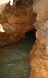
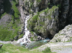
On to the Valle de Sobra and parked near the junction of two tracks 📌, one of which contoured around the hill for 300m to a cave/mine, which we explored to just out of daylight. Next we went down the steep track into the valley with the objective of following the rushing water and investigating a possible resurgence at a cliff face at the bottom. On the way we passed a small resurgence/stream with a cave adjacent which had obviously once been a cheese storage cave – with the remains of a few cheeses still on the shelves 📌. Continued on to the cliff face seen earlier from above; this indeed had an active resurgence with a passage to the left ending in a marbled pool 📌. A passage on the right was closed by a locked iron door. Followed the stream down to an impressive dam (1930s?), now not in use, and back up the steep track to the car, a hot 30-minute walk in full sun. Then on to Tresviso for a much-needed beer and lunch with a spectacular view over the Deva gorge. In the afternoon, retraced steps back to Arenas with a stop in Sotres to check out hotels for a possible base in a future year, then on to Llanes. Wandered around the town viewing the changes (notably the much-widened main bridge and extensive new pedestrianised areas) before a fine fish dinner (Merluza a la plancha and Merluza fritos) at El Cuera, washed down with Viñas del Vero ». |
| 10.06 | Internet café and a walk along the cliffs before lunch in Purón. Afternoon updating logs, etc. To Sidrería Cabañón » in Naves for dinner, not as good as remembered, perhaps because Sunday evening. |
| 11.06 |
A full-day walk planned, so an early start with a stop
in Posada for fuel and provisions. Then on via Arenas to Puente
Poncebos to start the classic 10km walk to Caín at 11:20. Starting
at ~300m, we reached the highest point of the walk (Los Collaos),
at about 565m, in 40 minutes and Caín at 14:40. As usual, the
walk through the gorge was outstanding, and the views spectacular.
All resurgences on the walk were gushing water due to recent rain,
with high-pressure jets of water especially impressive at El Farfáu.
After a pleasant lunch we investigated the resurgences across the river 📌; they turned out to be lots of water issuing from a boulder heap. Back down the gorge to Puente Poncebos in 2.5 hours, arriving there at 17:00. Perfect weather and scenery. Typical paella in Uría. |
| 12.06 | Tuesday. After the hard walking, hard
driving. Left Llanes at 09:30 on the autovia going west towards
Oviedo. Arrived in the mining town of Langreo at 10:30 and continued
up the Nalón valley to the
Cueva Devoyu, arriving there at 11:15.
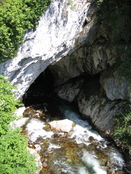
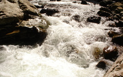
The water at lower entrance was deeper than in 2006, requiring swimming almost immediately, so we drove up to the sink (300m away) noting that the bar was closed. As we marched to the cave, the ‘speleo police’ (in the form of the Guardia Civil) drove by and smiled at our incongrous impedimenta. Access to river level, about 12m below the road bridge, appeared difficult due to the steep banks and undergrowth. However, Bill spotted an “easy zig-zag path” taking a direct route from the bridge to the left bank of the river at the sink; this led steeply down through the woods (branches providing an essential hand-line function) and we soon reached the southern side of the cave entrance. Whilst hands were dry, we took photographs and measured altitude (598m – possibly too high by 40m). The torrent was carrying a prodigious quantity of water (estimated 3 cumecs). We were quite prepared to get wet; in fact Bill was equipped with swimming trunks and waterproof ammo box. However, the current was strong and safe progress could only be made by holding onto the left wall. Near the entrance, of course, the river-bed boulders were slippery, with steep and powerful rapids. Beyond the rapids there was a deep pool with no shallow banks nor shore. The cold water was certainly exhilarating, and courage was not lacking, but prudence prevailed and we made a slow retreat back to the car. Moral: it might be possible to return in drier weather, but wetsuits would be advisable because the chance of losing one’s balance in the torrent appears high. A long light (floating) handline might be useful to avoid being sucked into a sump or undercut. After changing out of wet clothes we proceeded up the valley towards the Tarna pass (1490m) and on to Riaño for an excellent lunch at El Mesón: asparagus and chuletillas for Mike, Manchego cheese and gammon for Bill. Arrived back at Llanes at 18:00 via Beyos gorge – a total of 313 km. Dinner at El Almacén – fritos de merluza and fresh anchovies, etc. |
| 13.06 | Plan A – visit Cueva Buxu (an archaeological
cave, so free on Wednesdays). It was closed due to a local fiesta
(but we did have a good walk to the cave and back).
Plan B – visit Cangas de Onís to replace shoes, and other shopping. Cangas turned out to be where the fiesta was – so everything was closed. Plan C – a beer in Arriondas – was successfully accomplished. Lunch about 10km west of Arriondas and just east of Sevares at Rte. La Roca was good. We then circled north to the coast to look for Cueva Sidron (found the Reserve but did not locate the cave itself) and to view the Sierra del Sueve from the west. Next back east to Niembru to look for the resurgence Steve Newton found in 1975 – we found the river, but without the Llanes map decided to leave the resurgence for another day. Dinner of merluza at El Cuera. |
| 14.06 |
Rain overnight. Objective Rales (Fuentica)
Main Chamber. Changed into full caving gear (new black waterproof
bike overalls for Bill) then a 10-minute brisk walk up to the familiar
Fuentica entrance, with rope ladder, full SRT, 20m rope, ammo box.
Took photos while hands were still clean.
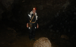
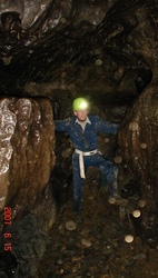
Squalid piles of decaying flood debris contained very lethargic toads which risked being squashed underfoot by the cavers. 50m or so before the sump a major dry sandy passage ascends on the left which we climbed with minor difficulty until we were some 20m above the main passage. Unfortunately, the route on was not clear. A maze of side passages often muddy, sharp, and with exposed climbs (requiring slings for handlines) tired the explorers (who were carrying tackle too). A descent was reluctantly made after over an hour of fruitless search. After washing at the stream next to the sump, we took more photos. Out at 12:30, changed behind a convenient wall in Rales, and washed at the spring on the old road.It begins to rain, heavily, so much so that we decide not to get out of the car at El Sucón. Lunch at El Mazuco – absurdly large filete de ternera, tasty but impossible to finish. Later (after a quick dash back to Rales to recover ammo box and camera left at the Spring) went for short walks and sightseeing, first to locate and photograph Bar La Roxia at La Pareda 📌 (lost and found several times over the years), then the Bufones Las Arenillas at Puertas de Vidiago, and finally the nearby Idolo de Peña Tú, the latter with fine views of the hills above Purón. Then it began to rain again, even heavier than earlier, and so torrential that it was hard to see the road; waterfalls cascaded down steps and jets of water burst out of walls. The downpour forced a choice of restaurant that one could drive up to and dash to the door; a pleasant light meal of Gambas al ajillo and Pixin a la Romana was had at the Parrera at Niembru. |
| 15.06 | First objective the ‘Vizcaina sink’ (probable
top sink of the Rales System). Descended a track past Vizcaina
and crossed many cow fields and electric fences before finding it
directly below L’Acebal 📌 – much
better approached from there.
Next, armed with a sheaf of photos, on to El Mazuco for a third attempt at finding Rafa’s Cabaña from 1986. This time headed for the depressions above Alto de la Tornería, and after a while recognized some field patterns, a limestone hillock, and finally the cabaña 📌, subtly altered with new tiles, new pointing, new chimney, railings, and the distinctive tree much reduced. Left a note for Rafa just in case he is still the owner. Two objectives, and some good walking, attained; time for lunch at El Sucron. Soup, chickpeas, baked fish, and a postre of a plate of three excellent cheeses, plus wine, mineral water, and bread – all for €7 each. The afternoon objective was to locate the bar La Cueva in Nueva which Bill frequented in 1975. This turned out to be in Villahormes, not Nueva, and the owner kindly found fuses for the lights and gave us a tour (the bar closed four or five years ago). It is extraordinary in being a bar wholly within a cave – with two entrances and inviting side passages 📌. |
| 16.06 | Beautiful clear weather with light cloud,
so up to Sotres and along the track towards Áliva to Vegas del
Toro. On foot up the valley to the west surrounded by limestone;
soon noticed and investigated ‘cow shelter’ caves 📌 – but no passage.
Back down to the track and then to three kilometers east of Sotres
where we found a mildly interesting sink 📌 with a 3m shaft and a deeper shaft on the other side of the
road 📌.
After a lamb lunch in Sotres, down to Arenas for shopping and a visit to Jim Thomson’s hotel (see 2005); he was in this time and gave us directions to Cueva Llonín for next year. On to Cangas to complete shopping, then north for an initial reconnaissance of the east side of Sierra del Sueve, hampered by poor maps. Finally to La Cuevona de Cuevas where we completed four through trips of the 250m cave – two on foot, and two by car – plus a fifth through trip in a side arch. Cabañón for criollo sausage and costillas (pork ribs). |
| 17.06 | Packed and headed east; first stop Cueva El Soplao » – a show cave with mine-train entrance which is
essentially one long (600m) chamber with spectacular calcite amd
aragonite decorations; worth being herded.
Lunch at Hostelrie de Ruente; pleasant service and good food, as always (menú €10). East some more with a stop to pack bags then on to look at the resurgences in the Asón valley. The whole river, almost, appears from resurgences on both sides of the river over a few hundred metres 📌. Explorations complete, so on to Castro. Merluza and anchoas rebozado, both excellent, washed down with an atypical, almost South American style, Viñas del Vero Gewürtztraminer. |
| 18.06 | Monday. Left Castro slightly ahead of schedule (08:30) but were soon caught up in the predicted rush-hour traffic jam on the motorway. Fortunately this started before the Santurtzi exit so we were able to divert onto the inland road (N634). Rejoined the motorway after Trapagaran, just in time for the airport exit, and arrived at the airport 09:35. Here we were greeted by a cacophony of sirens and whistles generated by a mob of football fans camped in the centre of the check-in hall; they had been there since 5am, apparently. Bill, wisely, heads off towards Italy... |
Personnel: Bill Collis & Mike Cowlishaw.
Notes:
- Exchange rate: 1.47; 67.9p = 1 Euro = 166 pesetas (245 pts/GBP).
- Weather: mostly very good, rain only at night except 14.06.
- GPS (Garmin Geko 201), positions in °,′,″ shown using WGS84 datum.
- This log was edited in the field on a Nokia N800 Internet Tablet », using the MemoWiki » extended Wiki notation, which is then processed by a Rexx » script to generate the HTML for this web page. On return it was then copied to the Speleogroup MemoWiki, from which a ‘static snapshot’ is directly published to the www.speleogroup.org » website.
