

Introduction
Site list (GPS fixes) Walks (GPS tracks) Video clips Panoramas
Electronic projects:
Bat detector
Lamp tests
µ-controlled lamp
SEPIC-based lamp
ISP isolators
Making SMT boards
Expedition logs:
Spain 1973, 1974,
1975, 1976, 1977,
1979, 1982, 1983,
1985, 1986, 1987,
1988, 1989, 2000,
2001, 2002, 2003,
2004, 2005, 2006,
2007, 2008, 2009,
2010, 2011, 2012,
2013, 2014, 2015,
2016, 2017, 2018,
2019, 2020, 2021,
2022, 2023
Mexico
New England
Translation:
Expedition log, Summer 1982
A transcription of the Speleogroup logbook.
La Franca base. Caving around Suarías, and the exploration and
survey of Toyu and the Latarma valley etc.
| Date |
Activity |
||||||||||||||||||||||||||||||
|---|---|---|---|---|---|---|---|---|---|---|---|---|---|---|---|---|---|---|---|---|---|---|---|---|---|---|---|---|---|---|---|
| 11.07 | Sunday. Left Winchester in Pete’s car
at 15:00, with Liz, Pete, and William; the day the SS Canberra
arrived home at Southampton »
from the Falklands.
Stopped for cream teas in Honiton, and were overtaken by the beginnings of the convoy taking the Royal Marines home to Plymouth. From there on, every bridge, every lay-by, every possible parking place was full of people waving flags and cheering the soldiers home. The entrance to Plymouth was just a mass of people – the three-lane road and roundabout reduced to a single lane by the press of people, cheering and waving flags. Just behind us was the main convoy of a hundred coaches. What an occasion! And quite unexpected. Fortunately the campsite was nearby: set up tents in the beginings of rain. Explored Plymouth and Plympton once the crowds has dispersed. Thunderstorms. | ||||||||||||||||||||||||||||||
| 12.07 | 15 minutes from campsite → dock, arrived at 7; on boat by 07:25. Blowy and foggy to start, but breeze and fine weather by Cape Finisterre. Boat a little smaller than expected. Whiled away the day in the sunshine. | ||||||||||||||||||||||||||||||
| 13.07 | Up at 05:50 (06:30 Spanish time). Breakfast;
off boat by 07:30 local time [presumably Brittany ferries to
Santander]. Reached Altimara at 09:40, museum opened at 10:00
– but the cave proper is no longer open to visitors, so visited
the Cueva de Stalactitas – surprisingly well worth the visit.
On to Santillana del Mar to meet Bill & Elsa. Not at the arranged meeting place at 12:00, nor at 13:00, so sat in a bar and then had lunch (not bad, 500pta.) in Hotel off main square. B & E met at 14:00 – they had just missed us at 13:06. Off west, visited various campsites and hopeful beaches, eventually decided on La Franca. Put tents and mansion up just before it started to rain again. Supper Spag. Bol., courtesy of Elsa. Early night. | ||||||||||||||||||||||||||||||
| 14.07 | Slow start. Unquera for shopping, then
through Panes and up the Deva gorge to La Hermida – stop for drinks.
Lunch at the hot spring (and small exploration of the spa). Up the
Linares Road.
Investigated “bloody awful” muddy depressions and sink at top of saddle above Navedo(?). No go. Interesting as hill is above some kind of sh*tstone. Down to La Fuente, then down the Lamasón valley to Venta Fresnedo. Horse flies. All six walked up Latarma (Tama) valley; little William not too keen, even when carried. First stop was resurgence of second system – draughting very very strongly: a wet and very interesting possibility. On up the path, took a direct line instead of staying on the track, and thus spent the next hour thrashing about in the bush and generally going in circles. Eventually back to track. B&M went on up to third system, explored rather uninteresting young cave (sharp, spikey, boulder ruckles), about 80–100m of passage. Back down the hills to Venta Fresnedo, following the proper track this time! To La Franca via various routes, beach, etc. Paella for supper for all at the campsite restaurant (~500pts each for meal).
Altitudes taken ±5m:
| ||||||||||||||||||||||||||||||
| 15.07 | English sausages for breakfast. Pete off
on expedition to Santander (successful) to get car exhaust fixed.
M, B, & E join Liz and William on the beach for a couple of hours
(bright but overcast); then up via Columbres to Panes then Suarías.
Track up the hill much improved: drove to top for photos of the
major depressions. Then back down hill a little to junction of track
and then down to Cabañuca
entrance. Explored easy dry series and also start of (dry) streamway.
On the way back to the car investigated obvious entrance to cave on end of spur: an old phreatic cave, much re-dissolved, about 60–100m of passage, mostly explored by locals according to foorprints. ¡No horse flies! Back to campsite.
Altitudes measured:
| ||||||||||||||||||||||||||||||
| 16.07 | Overcast (again),
drizzle later. B, E, M, P drove up to Suarías via boltless [for
carbide lamp brackets] Unquera, where a doomed fiesta was starting.
Took track from Suarías to smelly sink which resurges to sink again
near the bottom of the large depression below the village – cave
called La Redonda. M, B, P entered, clutching noses. Natural arch
at entrance, water-avoidance possible until small fall and pool about
30m in. Too noisome to continue.
Thence via Golf-GLD-testing hill to track on ridge above Cabañuca resurgence – Bill set off to altimeter the resurgence while Mike & Pete explored next closed valley W (after all had investigated rock shelter on R at top of latter). Bill wandered around, echoed, and waited in car with Elsa while M & P first tried several possible spots for caves until finding one just before the very bottom (2×1m entrance on R, length 6m to flat-out crawl). Then into real cave at bottom of depression: followed for about 20m of high passage to choked sink which M pushed for a further 5m before it got too grotty. Upstream found 2 resurgences from boulders – Mike gave himself a mud shower near one. Then further W found a collapse amongst bushes 1×1×1m, but indications of a passage below.
 Cueva del Arco
Altitudes measured:
| ||||||||||||||||||||||||||||||
| 17.07 | Circumnavigation of the Picos in search
of sun. Panes → Potes → Riaño → Cangas → Arriondas → Llanes.
Cloudy and overcast up through the Deva gorge, and in cloud at the top of Puerto de San Glorio. Magically the sky cleared on the descent from the pass – blue skies, little white clouds, blazing sun. Diverted north at Portilla de la Reina – again cloudy north of Puerto de Pandetrave, hot and sunny to the south. On to Riaño. Pico Yordas (to the west of Riaño) looks an interesting limestone area. There is a campsite at Riaño, although the town was dull and much smaller than expected. North to Puerto del Pontón and cloud. Down through the Desfiladero de Los Bejos – very impressive. Then Cangas, and Arriondas (Bar/Resturante San Remo) for 350pts menú del día. Back to campsite via main road. | ||||||||||||||||||||||||||||||
| 18.07 | As a nearly-sunny day, Bill, Peter, and
Mike decided to do a wet cave – namely Cororigo, the second Tama
valley cave system, whose resurgence had been strongly drafting when
investigated on Wednesday. Bill was ready in his brand new wetsuit
first, so in he went to check that there wasn’t a sump just round
the corner. He did not reappear so presumably the cave continued
beyond the entrance pool. (This pool must be navigated by swimming;
Mike, who did not have a wetsuit, was not amused.)
When Mike and Pete appeared, Bill was returning from the depths of 50m of streamway complaining that the cave seemed to have come to an end althought there might be a bypass. Indeed there was, as Mike found on the left of the rift. A few squeezes soon found us again in big, drier, walking flood streamway. Down, the stream was again reached but a crawl up at stream level closed down rapidly. Underneath the flood streamway the stream cascaded down for 30m but was not followed further (too slippery!). Above and via a pool a few dry passages (draughting boulder choke, etc.) were followed without success. We surveyed out. Overall time underground 4½ hours. Way back via Lafuente for 2 vinos each and chat to landlady who informed us of Madrid speleos. Drove back by Puente Nansa. (Surveying notes, Cororigo: Tape–PJR, Compass/Clino–WJMFC, Notes–MFC. BCRA Grade 5 for most; some lower therefore Grade 4. Bill’s compass readings may have been distorted by his magnetic lamp reflector.) | ||||||||||||||||||||||||||||||
| 19.07 | All to the beach (after shopping) to watch
Bill snorkel: a fine, hot day. All remained on the beach except
Bill, who went off to Suarías alone and walked up from the Cabañuca
area towards the Honda del Valmayor. The climb from about 300m to
the saddle @ 770m took about 90 minutes. There were depressions
of various sizes everywhere, but only the bottom of the Honda was
investigated. The Honda itself is a steeply-sided depression with
a small stream which sinks in a cliff face. There is tufa deposited
in the stream suggesting that the water comes from springs, and that
the cave if any at the sink will be poorly developed. At the other
side of the sink I [Bill] expected a resurgence. On no.
There was yet another sink in the cliff face taking a small stream @ 592m.
The valley is very flat at this point at about 595–600m until a
shallow depression near buildings marks the beginning of a gentle
slope (at first) down to the Deva Gorge.
There are lots of horses, foals, cows, and calves. Near the buildings (really half-abandoned barns) there is an obvious cave entrance, 3m wide, wide cows like to shelter from the sun. It only goes for 10m unfortunately, and is full of cowsh!
Robertson mega-curry (chicken) for supper. | ||||||||||||||||||||||||||||||
| 20.07 | All to Llanes for shopping and lunch. Busy
in the town, so both parties successfully managed to avoid each other
in town for 2 hours. Market day (Tuesday).
 Bill and goat Down to Cangas (via stop at basket shop), then to Arriondas to complete piggery for the day with fabada, merluza (hake), and flan. P investigated hole overlooking campsite: an epic ascent of vertical gorse bushes led to 4m of unmemorable passage. | ||||||||||||||||||||||||||||||
| 21.07 | A late start (14:00) then B, M, P back
to Suarías depressions to survey Cueva el Arco (found on 16.07).
Mike directed east up the hill to circle up above the cave through an area of limestone and tree outcrops stretching up the hill – not productive. Fine views, though rather hazy. Chased down the hill by descending mist (which fortunately retreated later) and joined the others in the cave – they were just finishing the survey. B & P entered the cave at 15:00. A quick dash around the cave with new carbide lamp (Petzl piezo-eletric lighter worked well), and all retreated back down the hill, checking some depressions on the way. Some promising digs, especially on the line of weakness which may well be a continuation of the features which formed C. el Arco. The rough walk down the hill left all feeling somewhat knackered. Arrived back at 19:00 for noodles & cider supper, followed by a cards session in the Bar. Campsite ↔ Suarías in ≈30 minutes. Altitudes: Underneath the arch 463m; cave entrance 465m; bottom of cave (in trench) 449m → approximate vertical range 16m. Later note: this cave possibly explored by geologists attached to ICCC expedition in Easter 1976 (‘Clog’, Jonathon, Mark), based in Suarías. Also this sounds exactly like the cave described by Bill in the 1975/6 OUCC report ». | ||||||||||||||||||||||||||||||
| 22.07 | Extended breakfast. P, E, W drove west:
La Franca → Puertes, then back and down Cueva Pindal (show cave)
“worth a visit”. B & E beached, dug dams, etc.
M also beached (dams) then east along railway line to near station. Up hill (gorse) to top of hill and open fields and view of the sea. Along hill/cliffs towards campsite: unfortunately fields and track did not go the whole way ..... next two hours spent thrashing through gorse/bramble jungle, including a 30′ vertical descent and 50′ vertical ascent through gorse to cross a ravine. Eventually attained fields at back of La Hacienda, and so back to campsite. [Gorse thorns still popping out of skin 2 months later!] | ||||||||||||||||||||||||||||||
| 23.07 |
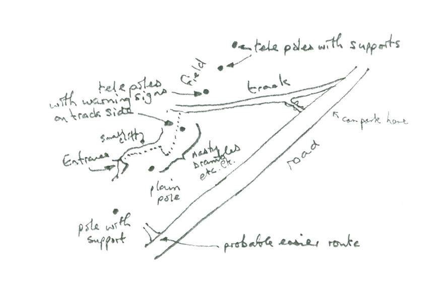
 Into wetsuits for Toyu Rather less water than in previous visits. Laddered pitch one from natural belay (5m), across pool (*¡warning: slippery rocks!*) to top of second pitch. Used 1979 bolt for belay (spreader). Ladder (12+ m) down past awkward slot through heavy spray to final 3m of free hang into waist-deep pool with tree trunks. Unusual rock lips at bottom of the shaft. Around pool, to left (where water sinks into sump pool) sandy area is devoid of passage. Ahead and to the right small inlets provide pleasant winding passages but no real prospects. Further to the left (across deepest part of the pool, which can be skirted) two routes lead into a complicated area of spiky rock. Two parallel ascending rifts may be followed up for some tens of metres to a draughting area probably very close to the surface. Various aural connections between the rifts can provide amusement. At the bottom of the two rifts, scrambling through the rocks eventually leads to the downsream side of the first sump pool. Sumps again from pool. Small tunnel up on left leads to rift traverse, past further sump-sump pool to yet another pool in small chamber. From there large short passage to another (deep) pool! Stream sinks soon after. Ascending slope at far (downstream) side leads to a large boulder slope in very large chamber. Mike looked around lower down, finding likely way on on the left. Pete looked for way over the top. Several possible-but-unlikelies, then a 3m climb led to attractive banded grey rock and a 3m × 10m wide flat-floored passage. Boulder slope at end led to bones, warmer air, and a 1m × 2m entrance into bushes! I [Pete] went out to check location (see sketch) then back, with difficulty in finding right hole to top of boulder chanber. Exit somewhat laborious with 1½ lights. Pitches wet, and awkward at top. Visited entrance series of new entrance on way back to the car (sketch). Various bones, and generally potentially archaeological, but no paintings etc. seen. Not a bad trip: worth a Guinness anyway. (Grade 1 sketch survey later in the log superseded by later surveys.)
Altitudes:
Thus vertical range ≈42m (but note that the stream resurges downriver from where the altitude was measured). On way back to campsite investigated amazing hole close to road (able to light with car headlamps!) just before bridge over Río Nansa. Large hole with rubbish, but no way on. “Good dig.” | ||||||||||||||||||||||||||||||
| 24.07 | General laze. M festered. B & Elsa walk
up Latarma river valley in the afternoon to take altitudes etc.
Pete & Eliz went to Ribadesella and Tito Bustillo.
Some altitudes taken during Tama Valley walk:
P & Eliz found area on back road between Ribadesella and Arriondas had promise (road through La Vita). | ||||||||||||||||||||||||||||||
| 25.07 | Hot and sunny; all to beach in the morning.
Then P, B, M attempt to have the menú del día at the campsite
restaurant. One-and-a-half hours later, leave for the Tama river
valley.
Down the new (Pete’s) entrance, surveying in. To small chamber near the entrance, left some passages for later. Down to main chamber, surveyed down right-hand side and up left. Then investigated M’s possible way on, which just led back into the bottom of main chamber (via flood debris – green squeezy botttle – wedged half way up chamber!). P & M then explored tubes close to the bottom sump – one possible lead, needs wetsuit. Tight in places. Then surveyed across pools, back to main chamber. Investigated the complex of passages (“Amazing Place”) at the top of main chamber. Back up to entrance chamber; checked out small tubes to S. of chamber. Rift didn’t really go, other holes led to pretty tubes and stals. B & P then went up passage to N., while M floundered around in the dark, which led via classic keyhole passage to a new (third) entrance. All then surveyed out of this entrance, since it opened out into green field instead of gorse and bracken; near barn. Out at 9pm. An obvious hole in the field, up-valley from barn entrance, is a crawl in phreatic tube with tight leads leading off, not pushed. 5-hour trip (approx. 2 hours exploration). 42 legs, approx. 380m. All agreed quite enough for one trip! Dinner at El Horno. More expensive and better than average. | ||||||||||||||||||||||||||||||
| 26.07 | M, P, E, W to Fuente Dé. Fine and hot: good views, found a couple of “good digs”. Elsa sunned and Bill pottered about in the Tama river valley: found resurgence. | ||||||||||||||||||||||||||||||
| 27.07 | “Early start” (11:15). Hot sun. P, B,
M to Toyu to continue survey.
 Toyu barn entrance Grand Guinness Ceremony followed, sitting near the sump pools and duly recorded on film. Exited via barn entrance (short re-survey on the way), looking at sundry holes and side passages on the way. Still various leads to be looked at. 6½ hour trip. 45 legs in about 3½–4 hours. Dinner for all at the campsite. | ||||||||||||||||||||||||||||||
| 28.07 | Packing for P, E, W. B & M back to Toyu.
Looked at small hole, then surface survey from barn entrance → Pete’s
entrance → resurgence. Resurgence interesting with several holes
among boulders, including one with a definite cavey draught blowing
out. Probably didn’t go.
Back by 8pm, then all to El Horno for the Expedition Dinner. | ||||||||||||||||||||||||||||||
| 29.07 |
 Cares Gorge Supper in Acuario, coffee in Café Moderno, in Posada. Torrential rain and thunderstorms all night. Tents leak! | ||||||||||||||||||||||||||||||
| 30.07 | Fortunately dry in the morning, then later hot and sunny with a stiff breeze – ideal drying weather. Off to Llanes for shopping and lunch (paella). Lazed in the sun for the afternoon. (Last entry for 1982.) |
Personnel: Bill & Elsa Collis, Mike Cowlishaw, Pete, Liz, & baby William Robertson. Parts of this log were written by Pete.
Other log details: Exchange rate 189 pesetas/GBP. Sketch survey of Toyu dated 24/7/82. Exploration points system (and scores for 1982 caves).