

Introduction
Site list (GPS fixes) Walks (GPS tracks) Video clips Panoramas
Electronic projects:
Bat detector
Lamp tests
µ-controlled lamp
SEPIC-based lamp
ISP isolators
Making SMT boards
Expedition logs:
Spain 1973, 1974,
1975, 1976, 1977,
1979, 1982, 1983,
1985, 1986, 1987,
1988, 1989, 2000,
2001, 2002, 2003,
2004, 2005, 2006,
2007, 2008, 2009,
2010, 2011, 2012,
2013, 2014, 2015,
2016, 2017, 2018,
2019, 2020, 2021,
2022, 2023
Mexico
New England
Translation:
Expedition log, Summer 2016
Cicera, Trumbio, Cobijeru, Vega de Hibeo, Toyu.
Click on, or tap any image thumbnail for a full-size version, or on a video clip to play at a larger size.
| Date | Activity |
|---|---|
| 07.06 | Bill leaves home at midday and drives 200 km to Bergamo. Flight on time and arrives at
Santander early 19:20. Collects car, phones hotel to advise after-midnight
arrival and seeks advice on where to eat nearby at tourist kiosk
in the airport. Mike passes the arrivals exit at 22:05 and we proceed
(as recommended) to Liencres where we end up at a rather unpretentious
Bar Casa Carlos. But the food was remarkably good – and we were
hungry. Lomo for Mike, and jamón for Bill plus good chips
all washed down with Ribera del Duero.
Arrive at Llanes around 00:45 and after a quick walk round the town we checked into the Montemar Hotel. |
| 08.06 | Walked into town in search of breakfast and settled on the Xana bar by the estuary for
café con leche and an enormous slice of tortilla. The weather
was overcast and the Sierra de Cuera was hidden behind the clouds.
So a drive south was planned, but near Puente Nuevo the sky had cleared
and we decided to drive up to El Mazuco. Parked at the paddock
beyond the village and contoured round towards Ojo del Río. Very
low water levels and the cave entrance was more exposed, but the
entrance pool prevented inspection of the passage.
 Bill at Collau Rubiera We ordered chorizo, criollo and patatas ali-oli (just 3 plates) but we couldn’t finish the excellent food. After a drink in “El Sucon” we returned to Llanes via Posada. For dinner we shared a plate of cheeses at ‘La Amistad’ but we couldn’t finish that either! |
| 09.06 | Grey drizzle in Llanes, so our automated response – head South – kicked
in. With the new motorway to Unquera open we were in La Hermida
in 45 minutes! As predicted we had left the clouds behind and we
were soon enjoying some picón (queso de Bejes)
in the sun outside Posada La Cuadrona.
 Riega Cicera Descent was much faster, for a total walk time of 2:45 (track), and we arrived back in La Hermida a little after 3pm – in time for lunch (sopa and escalope). Back to Llanes via Urdón and along the Cares Gorge, stopping at La Molinuca at the road leading to Cueva Llónin, etc. Shared a dish of Fritos de Pixin at Rte. Salero, for dinner. |
| 10.06 | After the previous day’s walk we were feeling that more caving and less walking might be in order,
and as yet again the skies were overcast we planned on Cueva del Trumbio. The big cave is notionally only 10 minutes from
the road south of Covadonga to the lakes. However a previous attempt
in 2012 had failed as the entrance depression had been completely
overgrown by gorse.
Perhaps in previous decades, the gorse was kept under control by cows but EU policy has been to reduce the butter mountain by reducing the dairy industry. This has had the side effect of making cave entrances less accessible! To add to the obstacles the access field was very wet and muddy and protected by barbed wire. Bill managed to lacerate a finger as a branch he was holding on to turned out to be rotten. (Nothing too serious, a clean wound.)
 Cueva del Trumbio entrance Honour satisfied and after a few photos we retraced our steps. The llosa did not reveal anything of speleological interest but is full of little sinks. As we walked up through the gorse there was some slight drizzle; welcome, as we were warm from our exertions. Lunch in Casa Morán, Benia, recommended for its excellent fabada, followed by lamb. Good quality food for a menú del día but pricey at €38 for 2 including Ribera del Duero. Back to Llanes via Posada and autovía. Dinner at El Almacén, bocarte (fresh anchovies) for Mike and boletus mushrooms in Picón cheese sauce for Bill. |
| 11.06 | Glorious weather, sun with some cloud, 20°C. As it was Saturday
we decided to avoid busy places such as the Lakes or Bulnes, and
headed to Tielve to reconnoitre possible tracks towards Valfrío,
to start us up towards the Majada de Tordín. A steep concrete
track led invitingly NE from the village, but it was exceptionally
steep and very soon the rental car declined to proceed further.
A complicated team effort succeeded in executing a multi-point turn
and a safe descent.
We decided the weather was ideal for a walk above Sotres, and headed East. At the hairpin bend junction below Sotres, however, was a large coach, blocked by cars parked on the bend. Unable to go up, we turned off and went a short way along the track towards Áliva to turn, seeing a number of tired runners and spectators. After many dusty hill starts, etc., we made it back to the hairpin bend and were able to depart down the hill. Meanwhile a stream of vehicles – and a second coach – were joining the long queue that was trying to get up the hill. Very relieved to have open road, we returned to Arenas where we discovered we had stumbled onto the final stages of the Travesera de Picos De Europa, a 74km(!) run that started in Covadonga at midnight and whose first runner arrived in Arenas as we were there, 13 hours later.
 The Arenas–Ortiguero road Back via Rales, but did not meet any of our old friends. |
| 12.06 | A bright day but rain forecast. After breakfast at Bitacora, drove east towards Buelna on the old autovía
and stopped briefly near Pendueles after noticing some entrances
north of the road 📌. They may
be real caves but are clearly used by the local farmer and his animals
so were not accessible.
 Cobijeru ‘muddy cave’
 Cobijeru inland beach, Buelna
 Cobijón cave We had an excellent menú del día at “Restaurante Las Filipinas” in Comillas followed by a detour to Camijanes on the way back to Llanes. |
| 13.06 | Despite a poor forecast and ominous clouds, the sun came out and we
headed to the village of Póo de Arenas (1.7km WNW of Arenas).
After crossing the river, tracks to the west zigzag up the side of
Peña del Alba, which has inviting cave entrances in its cliff faces.
In 1975, Bill and Steve Newton found a cave possibly near there.
No such luck in 2016, although a very pleasant walk was had, with
wildflowers, butterflies, and lizards in abundance.
 MFC tucking in to fabada in Ribadesella |
| 14.06 | Another sunny start, so off to explore a depression recently noticed on the map: Vega de Hibeo (track). Two km south of Meré, a narrow metalled track crosses Puente Cima Cosagre and hairpins up to Ilcedo. From there a pleasant and steadily ascending walk along a limestone boundary took us up a little over 200m in 2km and 1:20, reaching a grassy col overlooking the quite idyllic Vega, with grazing cattle and horses.
 Vega de Hibeo To El Sucón for menú del día, €9 each, of which the highlight was salmón a la plancha. Rain started while we were eating, and more arrived later in the afternoon, but it was beautiful walking weather in the morning. |
| 15.06 | First part of plan was a photo trip in Cobijeru cave at Buelna.
Drove there using the (deserted) old autovía and arrived just as
a coach disgorged dozens of schoolchildren, many of them wearing
helmets. We ‘pushed’ the muddy cave a little further, then carried
on to the main cave. As we feared, a mound of day-sacks (guarded
by a teacher) indicated that a large party had entered the cave.
We walked around the cliffs for a while, then a short foray into
the cave showed that it was thoroughly misted-up and photography
would be pointless.
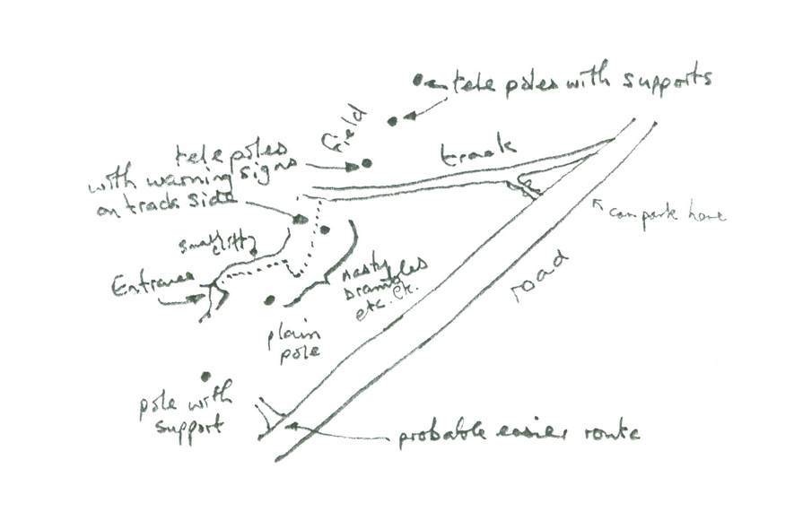
 Toyu ‘nettle entrance’ feature
 Salmon at Casa Gloria Key data secured, on to Camijanes for another above-average menú at Casa Gloria. Back in Llanes, analysis of the GPS readings and track conclusively showed that the ‘nettle entrance’ is not one of the top entrances to Toyu; instead it is the small feature, shown 120m SW of the barn on the plan and elevation of our 1982 Speleogroup survey, that we had overlooked. We also calculated predicted GPS positions for the ‘Cueva Roza’ entrance 📌 and the resurgence 📌. |
| 16.06 |  Bar “María Rosa”, Lago Ercina
 Lago Ercina in damp weather |
| 17.06 | Rain, so south again. New route (motorway + Bustio) to La Hermida
brought the driving time down to 40 minutes. Still raining, so the
planned walk to create a ‘SampleGPX track’ for MapGazer » became a drive from La Hermida to Bejes (track). Then to Potes, where the rain finally stopped, to buy a
map, etc. Given the improvement in the weather and not feeling like
going further south, we backtracked and headed north and east via
La Fuente to
Toyu determined to locate the oriental (NE) upper entrance.
 Cueva Toyu, inside NE entrance Well pleased, and with the wet weather blues firmly banished, we continued on to Casa Gloria for another pleasant menú. Back to Llanes via Pendueles. |
| 18.06 |  Inside Cobijeru cave After an hour underground we made some rough measurements of distance and bearings to be able to retrace our footsteps on the surface and found ourselves on the cliff above the lower entrances, 135m from the inland entrance. We had underestimated the length of the system, which we now guess to be at least 200m (rather than 70m).
 Cliffs over Cobijeru cave |
| 19.06 |  On the Pechon peninsular  Pijota at Casa La Aldea The western end of the peninsular proved to be inaccessible, so we retreated to Comillas for lunch; a reprise of 2014: spectacular pijota a la plancha (baby hake) and chiperones en su tinto at Casa La Aldea. |
| 20.06 | Welcomed by a bright blue sky we had a good breakfast at Cafeteria El Latino then drove east to Venta de Fresnedo for some caving in Toyu.
After changing, Mike GPSed 📌
the “Torca” behind the barn but did not descend as it was partially
filled with tree branches. We retraced our steps along the track
and turned south to the other top entrance through the gorse, brambles,
and nettles we had thrashed through on Friday.
 Inside Cueva Toyu After some difficulty route finding, we found our old route down via the second passage on the left. It seems some subsequent explorers (Carlos Puch?) had made little cairns of stones to mark the route. Nevertheless route finding was not easy but after 15 minutes we came to the climb marked as 5m on our 1982 survey. In those days this was an easy free climb (particularly when wearing rubber wetsuits). But 34 years later a hand line or ladder was thought necessary so we turned back to search for the “Torca” entrance and make a through trip. Back to the chamber ... but there were many possible passages to explore.  Urdón cave Changed, and drove to Urdón to look at the famous (The Highlands of Cantabria, Ross & Stonehewer Cooper, 1885) cave entrance there 📌 about 30m from the Tresviso path and the main road. We had not visited it before, and it turned out to be just 5m long so we could not even get out of sight of daylight! It was now 14:00 so we drove back south to La Hermida and enjoyed their €12 menu del día. Back to Llanes via Posada. |
| 21.06 | Evening flights in effect allowed a full day of activity, but with
gear packed reconnaissance was in order. Anxious to re-sample the
lamb at Espinosa de los Monteros remembered from 2005
 en route to Portillo Lunada On to Ramales to see if it would make a suitable base for 2017 (on the to-do list because of trips there in 1977), but it didn’t inspire. Ditto for Laredo, after a ‘10 minute’ diversion to check it out. Next to Solares to fill tank, etc., before arrival at Santander airport – again on schedule at 18:30. A very full day, with lots of driving for Bill over quite exposed mountain roads. Bill made it home at 02:00, Mike got to Stansted hotel (after an hour in passport queue) at 01:00. |
Notes:
- Exchange rate: 1.26 (compared to 1.425 in 2015); 70p = 1 Euro = 166 pesetas (237 pts/GBP).
- Weather: A few damp mornings, but otherwise very pleasant – around 20°C most days.
- The pictures in this log were mostly taken using a Panasonic DMC-TZ100
camera; its stabilisation and 1″ sensor allowed the cave photographs
here to be taken hand-held and lit by the headlamps we were wearing.
Also used (in Cobijeru cave) was a Manfrotto Muse LED floodlight. - Specific GPS positions are shown by a pushpin symbol (📌) in the log above – click on the symbol for a Google maps view of the fix. These positions are also listed on the Speleogroup site list page with coordinates in °,′,″ degrees using WGS84 datum and in UTM coordinates; see Coordinate systems.
- Fixes and tracks were recorded using a Sony Xperia Z3 Compact Android ’phone using the MyTrails app.
- This log was almost entirely edited in the field on an ASUS T-100 ‘Transformer’ notebook, using the MemoWiki » extended Wiki notation which is then processed by a Rexx » script to generate the HTML for this web page.