
Introduction
Site list (GPS fixes) Walks (GPS tracks) Video clips Panoramas
Electronic projects:
Bat detector
Lamp tests
µ-controlled lamp
SEPIC-based lamp
ISP isolators
Making SMT boards
Expedition logs:
Spain 1973, 1974,
1975, 1976, 1977,
1979, 1982, 1983,
1985, 1986, 1987,
1988, 1989, 2000,
2001, 2002, 2003,
2004, 2005, 2006,
2007, 2008, 2009,
2010, 2011, 2012,
2013, 2014, 2015,
2016, 2017, 2018,
2019, 2020, 2021,
2022, 2023
Mexico
New England
Translation:
Expedition log, Summer 2004
Bulnes, Cueva Bolado, Green Sink, etc.
| Date |
Activity |
|---|---|
| 11.06 | Smooth flights; Mike via DUS. Bilbao by 13:15. After the heat of Italy and the UK, 15°C, low clouds and slight drizzle are a bit of a shock. West to Ruente for lunch at 15:20, followed by a map hunt in Cabezón de la Sal and a return to Ruente for reconnaissance. Despite the low cloud it soon became apparent that there is very little surface limestone behind the Fuentona. On to Llanes; dinner at Rte. Covadonga. |
| 12.06 | Despite promises of sun, the day dawns
grey & wet. Head south via Meré to Arenas where it is still cloudy,
but no rain. New GPS batteries have mysteriously gone to low; Bill
finds he’s somehow broken his camera screen. Then south to the Bulnes
Funicular (€16) and up to Bulnes for a bite of very strong grey
cheese before heading south on foot towards Canal Camburero. Steep
start over slippery rocks and long wet grass to gorge in Canal de
Balcosín with a nice waterfall with a 8m climb on its left, made
quite serious by the wet (there is a bypass around to the west, we
discovered on the way down). Onwards past resurgence and then following
the stream bed (now dry) in thick mist. Our target was the Jou Bajo
at 1050m (about 2km and 400m above Bulnes). Turned back just short
of the target by an even more slippery and exposed climb. Arrived
back at Bulnes very soggy and very ready for lunch; Bill missing
some skin, Mike with strained knee.
Drove slowly back, with a stop at Caldueñín to check the water level in the cave; drier than 2003. Upstream looked possible but rather wet. LED lamps worked well. Dinner at Pescador in Llanes. |
| 13.06 | Beautiful blue sky and sun! Reconnaissance
trip in car: Llanes → El Mazuco → Malatería → Rales → Cardoso
→ El Carmen → Arriondas → Ribadesella. Took some photos of Bulnes
and snowy Picos from the Rales–Cardoso road. Lunch at La Parilla,
on the southern outskirts of Ribadesella—a good, if expensive,
fish restaurant. Anchoas, navajas (razor shellfish), pescado
vario (80€ for two). On the way back to Llanes stopped near
Piedra and walked around at the foot of the Sierra De Cuera where
there might be a resurgence, near the base of (and admiring from
afar) the zig-zag path up over the saddle of Collado la Prida to
‘Green Sink’ (OUCC 1970 »).
Had some sidra and then off to Sidrería Cabañón » in Naves (well signposted from near the Autovia exit at San Antolín), which we had discovered last year, for dinner. Lacón con patatas, chorizo criollo (sausages), setas con cabrales, and costillas (spare ribs). All excellent. |
| 14.06 | After checking e-mail in town, blue skies
beckoned us back into the mountains above El Mazuco. We drove up
the track nominally reserved for agricultural vehicles at La Tornería
(also a possible approach to Viango). First we descended SE over
a saddle into multiple depressions in woodland. There are no
streams and none of the depressions seemed likely to contain entrances.
Back up the hill again and to then descend SW towards a real streamway.
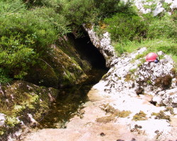
This comes out of a small sumped cave entrance, the Ojo del Río
(shown right; source of the Bolugas on the map). Looking east
from this junction of two valleys one can see a small cliff face
some 60m away in the central hill, as described in the OUCC 1970
report. Cueva a Sul is found here; two entrances lead to the waist-deep
pool which was not crossed.
Back up the hill again—there must be a better way to reach these caves! Lunch on the terrace at El Roxin bar in El Mazuco drummed up some enthusiasm to walk to Pozo de Fresno. This road was being improved in 2003 and is now suitable for cars, and there is an adequate parking place near paddocks some 400m from the village on the saddle overlooking the impressive Bolugo depression. Instead of turning west towards Fresno as planned, we explored east contouring above La Boriza resurgence and up the valley towards Cueva a Sul. This is a very easy walk compared with the aggressive vegetation and steep paths of the morning. The stream valley above Boriza is normally dry, but clearly takes a torrent in wet weather; flood debris has blocked the sink. Further upstream water appears in the stream-bed but sinks in boulders. This water emerges from the Ojo del Río making this route a mere 25 minutes easy walk from El Mazuco (15 minutes from the paddock). Back down to Llanes with a brief stop at Debodes to explore the cave in the shrine (Cueva de San Pedrin). Pescador again for dinner. |
| 15.06 | Market day in Llanes; Bill enlarges his wardrobe. Then west to the Deva gorge, stopping at Urdón for a pleasant walk up the gorge towards Trésviso. Back down, and on to the Spa at La Hermida (now a shell, but work still going on) to locate the hot spring under the spa bridge 📌. Lunch of now-traditional Paella and Chuletillas in La Hermida (Rte. Paquin, BUSS’ 1973 haunt). Next to Bejes to admire the stunning views and to assemble a 9-rung rope ladder/handline from the kit of parts Mike had recycled from earlier Speleogroup tackle. Back to Llanes. |
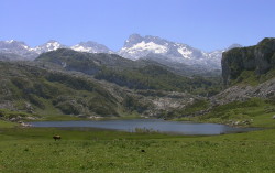
| 16.06 | A clear day so a trip to the lakes is planned, including various side roads around La Robellada and Corao (not speleologically interesting). Quick visit to the entrance of Cueva Campana in Covadonga for a GPS fix then up to Lake Ercina (right) for photographs and lunch at María Rosa. Decide to look for Cueva el Osu off the Ario track—without success—so we then complete the circumnavigation of the lake, investigating the extended cow-shelters at the SSE end 📌 and into Vega Bricial and beyond, walking for over 2.5 hours. From Lake Enol we drive to Pozo del Alemanó – a spring dedicated to “The German of Corao”, 1897–1997, near a pool where the river appears to sink. Back to Llanes by 19:00. Excellent tapas (fritos de merluza, patatas alioli, gambas al ajillo) at Rte. Terrazo. |
| 17.06 | A busy day; hot. As now mas o menos
4 weeks without heavy rain, the first stop was a ‘push’ trip in the
hoped-for-dry Caldueñín. Deep wading in painfully cold water
soon indicated that wetsuits were required. Out, and after dislodging
a herd of cats from under the car, side trips were made to check
out depressions in Buda and Villa. Little there, so off to check
out the cave at Buelna beach, the hot tip from discussions with locals
the previous evening. This turned out to be a rather short sea cave,
as feared, but left us close to Casa Poli for lunch.
Now re-energised, we head for El Cuevón de Pruneda, but are sidetracked to a new La Verde Purón establishment: semi-bar, semi-Adventure centre. There we met Pedro Cembreros, a caver for many years, who promised to send us a copy of the film segment of the Pruneda cave distributed by Lonely Planet. Pedro made some interesting remarks:
8–7–70 |
| 18.06 | Clouds coming in, so a good morning to
confirm the easterly route from El Mazuco and tie down the caves
from OUCC 1970. From the paddock at El Mazuco, we
locate the flood sink above Boriza 📌
and follow the cow paths to Ojo del Río Bolugas
📌. Then split and with the
aid of radios cover the full area of the SW side of the ‘hill in
the middle of the valley’. Mike’s knee is now fully operational,
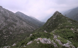
so he makes it to the top of the western peak, with rough karst and
spectacular views of El Mazuco and towards Viango (right). No caves
up there; but Collau Rubiera is on the southern edge of the field
150m above and SE of the Ojo, at N43°22'25" W4°49'58".
Back to the resurgence (Ojo) and the adjacent Cueva a Sul 📌 before retuning to El Mazuco by the same route, passing above (and to the south of) Boriza at N43°22'38" W4°50'35". Fine Fabada at the Rte. Roxia at El Mazuco inspires us to re-locate Pozu Fresno at N43°22'44" W4°51'20" and review possible drainage alternatives in view of Pedro’s suggestions from yesterday (we agree that Bolugo primarily resurges in Caldueñín). Back via Posada where we are amazed to find that ‘Becket’ still exists and is identical in layout to 1976, possibly even the same upholstery. Thunderstorms on arrival in Llanes. |
| 19.06 | Heavy rain overnight. After a quick coffee
in La Plaza in Posada, off to Purón with GPS. Cold wet walk over
sodden boggy ground to sink; El Cuevón de Pruneda at N43°22'35" W4°43'18". La Verde Purón closed so Llanes for
lunch. Back to Purón again and finally find Pedro at 19:00 and
have a long chat over maps about caves of the Sierra de Cuera, and
learn of the Cueva Bolado (Herrería) near La Pereda.
El Cabañón (Naves) for dinner and a quick recce trip to find Cueva Bolado. From the Llanes–La Pareda road, turn left about 0.6km after crossing the main N634 road. After 100m or so, some 100m before a quarry entrance, there is a widening in the track, with lake to east, to park. Go west over small stream (drain) and wooded path 50m to big walk-in cave entrance at N43°24'00" W4°45'56". |
| 20.06 |
A fairly easy start to the day: a trip to explore Bolado.
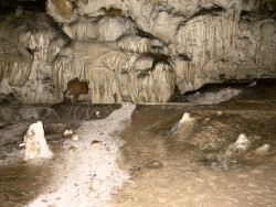
Mostly easy walking, some nice formations, also Civil war graffiti
and modern cave paintings. (Some ancient ones are in a gated-off
section of the cave.) Took photos, including the crystal-covered
flow shown at right.
Then on to Posada and Lledias to locate and follow the track up to the Green Sink. Only about 2km as the crow flies, but 250+m above the coastal plain. Muddy and very slippery in the woods, but clean for the top 200m vertical to the Collado la Prida, then a cow path along the depression. The sink itself is not penetrable, as expected, but Bill finds the hoped-for older entrance above and to the South of the sink, at N43°23'56" W4°50'18". The entrance is a 6m shaft 1m wide descending at some 50 degrees. It takes a small trickle of water. Not descended. Difficult walking down and a slightly different route at the bottom takes us across a dry flood channel full of deep sand, possibly similar to that found in Viango. Very hungry after the cave and 2+ hours walking we retire to Ribadesella for best-of-trip Fabada at Mesón Miño, now a regular of ours, to mull this over. By 4pm, we’re back to follow the stream bed (Arroyo) upstream. Soon reach a concreted resurgence/power station 📌 ... and then sweat up the fascinating dry stream bed until there is no possible chance of resurgences (in that area), though varous small holes and limestone swirl-pools were crossed. Get back to the car around 6:45pm and then to Porrúa for a very welcome cerveza. Spain vs. Portugal football match at 20:45, so Llanes in ‘ghost town’ mode, even more so after Spain loses. |
| 21.06 | Leave Llanes at 11:00; via La Borbolla route for another good lunch at Ruente (menú: large sopa montañes followed by lomo/chuleta, €7.50 each). Road to Ucieda investigated but no significant features. Arrive at Castro Urdiales around 17:00 in light rain. |
| 22.06 | Missed the airport turning at Barakaldo, executed a convoluted U-turn south of Bilbao, but still get to the airport two hours before Bill’s flight (4 before Mike’s). |
Personnel: Bill Collis & Mike Cowlishaw.
Notes:
- Exchange rate: 1.51; 66.2p = 1 Euro = 166 pesetas (251 pts/GBP).
- GPS (Garmin Geko 201), positions in °,′,″ shown using WGS84 datum.
- This was the first Speleogroup log recorded electronically in the field. We used an NEC 780 Handheld PC (chosen primarily for its ‘real’ keyboard, and also for its availability on eBay at low cost and dual Compact-Flash capability). The handheld only needed recharging once during the trip; a third CF card was used for independent backup. We edit the log using the MemoWiki » extended Wiki notation which is then processed by a Rexx » script to generate the HTML for this web page.


