

Introduction
Site list (GPS fixes) Walks (GPS tracks) Video clips Panoramas
Electronic projects:
Bat detector
Lamp tests
µ-controlled lamp
SEPIC-based lamp
ISP isolators
Making SMT boards
Expedition logs:
Spain 1973, 1974,
1975, 1976, 1977,
1979, 1982, 1983,
1985, 1986, 1987,
1988, 1989, 2000,
2001, 2002, 2003,
2004, 2005, 2006,
2007, 2008, 2009,
2010, 2011, 2012,
2013, 2014, 2015,
2016, 2017, 2018,
2019, 2020, 2021,
2022, 2023
Mexico
New England
Translation:

Pruneda ‘wet’ entrance
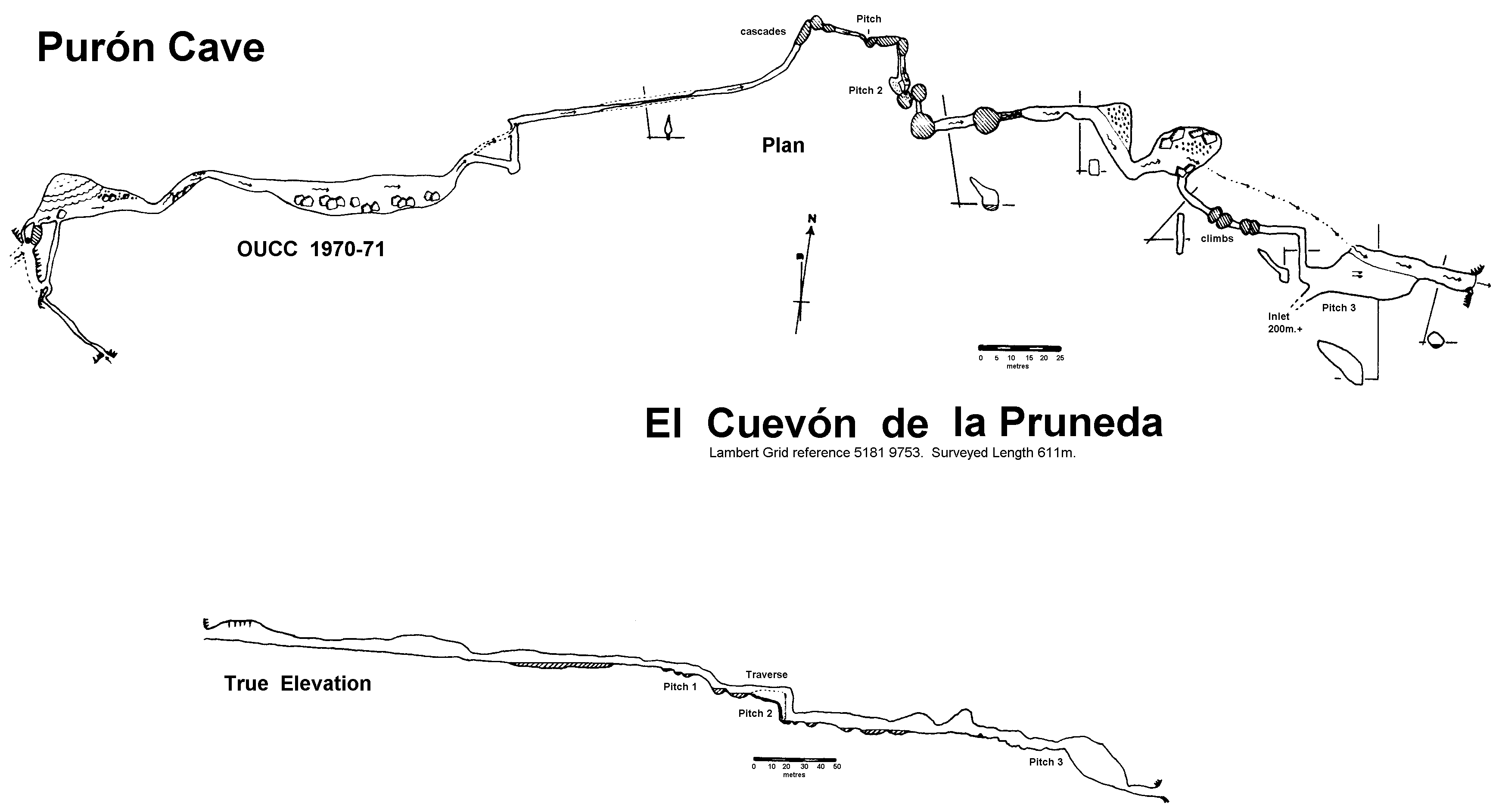
Name: El Cuevón de la Pruneda (‘Cueva de Purón’ in early logs and OUCC reports)
Location: 1.5km SW of Purón; sink of the Río Tornu, ~100m N of Soborrín cabin
GPS: N43°22'35" W4°43'18"
UTM: 30T 360.64 4804.26
Lambert: 5161 9753
Map: Porrúa (32-III)
Survey: OUCC 1970/71 » (mirror)

Water-worn limestone in Pruneda
Description: A through-trip stream cave with two upper sink entrances and (at least) three lower entrances, including the regurgence. Two pitches need tackle.
OUCC Proc. 6 »: “This cave was surveyed to Grade 3a and described to the then limit of exploration in the report of the 1970 expedition. The opinion expressed in that article, that a through trip would be improbable, proved to be unduly pessimistic, despite the logical premise upon which it was based.
The remainder of the cave was penetrated on July 20th, one party having entered by the sink as before, and the second entering by the resurgence; a through trip was made in each direction. The downstream party surveyed back to pitch 2 from the resurgence on their way out. Indeed the 1970 party had been almost within sight of daylight when they halted above the third pitch for want of tackle. The length of newly surveyed passage was 235 metres, giving a total surveyed length of 611 metres for the whole cave.
Briefly, the upper part of the cave begins with two penetrable entrances, normal and flood sinks, which lead to a large and boulder strewn passage. After narrowing at one point, the streamway develops into a series of cascades and pools. The first pitch is made up of two of these cascades, descending at a steep angle. The second pitch drops into another deep pool, the exit from which is a tall, narrow rift. This leads to a larger passage with water up to 1.5 metres deep in one long shelving pool, followed by a series of short cascades. The subsequent stream passage contains water filled potholes from 1 - 2 metres deep in the floor. Two large chambers, the first with a sandy floor, and the second with boulders, carry the stream to a small passage, blocked by substantial boulders. A large flood bypass, with several deep potholes, gives access to the third pitch, where the stream reappears. This pitch is in effect a scalloped slope, set at 30° to the vertical; a ladder as a hand.line is all the tackle required. A traverse from the top of pitch 3 leads to an extensive passage, which was not surveyed but which has an estimated length of 200 metres. This contains a number of small chambers at various levels. Because the passage is dry and muddy, the few decorations in this part of the cave are not particularly impressive. The route from the bottom of pitch 3 to the resurgence is wide, but liberally bestrewn with boulders and occasionally low roofed. The stream emerges into a small wooded valley from a cave mouth 5 metres wide and 2.5 high.”
Visits:
1983a – upper series in dry kit
1983b – to first pitch in dry kit, problems at the step/pool on the way back
1985 – wetsuit through trip, gorse route down
1986 – wetsuit through trip, explore lower entrances, etc.
2002 – dry series, LED light experiments; heroic reversing
2004 – GPS
2005 – discovered inlet passage; re-explore dry series, perception experiments
2006 – dry series, test 3W LED lamp; check out surface depressions to East
2013 – photographic experiments (3W lamps, 3D pairs, etc.)
2014 – some photos, etc.
2020 – abortive drone flight over resurgence
2022 – drone flight for spherical and other photos of resurgence
Other:
Since 2002 one can drive from Purón village up to the cave altitude; earlier trips were a hike up from the village/river.